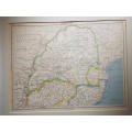
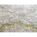
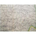
Map of the Transvaal - 1952 . Ref. No. MP/9
Check my rate
| Main centres: | 1-3 business days |
| Regional areas: | 3-4 business days |
| Remote areas: | 3-5 business days |
Product details
Description: Map of the Transvaal - 1952 . Ref. No. MP/9
Maker/Cartographer: John Bartholomew
Date: 1952
Description: From The Citizens Atlas of the World Published by John Bartholomew & Son Ltd. Edinburgh. Mounted on heavy board.
Condition: Overall in good condition. Very slight foxing is evident.
Dimensions: 47.5 cm x 60.5 cm.
Price: R260.00
Please note, I am NOT a qualified archaeologist/antiquarian and the description I have given is based on research of the subject.
Terms: We offer a strict three-day approval period from the date the parcel reaches you. Refunds/credits are based on the cost of the article, NOT including delivery charges. Please advise us within this period whether you would like to return any article for a refund/credit. Although we pride ourselves in our packing, the buyer remains responsible for loss, non-arrival or damage to goods being sent to, or returned.