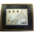
Framed Map of Cornwall by Thomas Moulle 1850
Secondhand
Shipping
Standard courier shipping from R30
R30 Standard shipping using one of our trusted couriers applies to most areas in South Africa. Some areas may attract a R30 surcharge. This will be calculated at checkout if applicable.
Check my rate
Check my rate
Free collection from
Somerset West, Cape Town
The seller allows collection for this item and will be in contact with the full collection address once the order is ready.
Ready for collection by Friday, 21 June.
Ready to ship in
The seller has indicated that they will usually have this item
ready to ship within 3 business days. Shipping time depends on your delivery address. The most
accurate delivery time will be calculated at checkout, but in
general, the following shipping times apply:
Standard Delivery
| Main centres: | 1-3 business days |
| Regional areas: | 3-4 business days |
| Remote areas: | 3-5 business days |
Returns
Get it now, pay later
Seller
Buyer Protection
Product details
Condition
Secondhand
Location
South Africa
Print Type
Drawing Print
Bob Shop ID
615793883
Title: Framed Map of Cornwall by Thomas Moulle 1850.
Publisher: Barclays Complete and Universal English Dictionary.
Format: Framed Map.
Height: 36cm.
Width: 43cm.
Info: An attractive map of Cornwall from Thomas Moulle produced in 1850.
The well-known series of County Maps which are known as 'Moules' were first published in separate sections for each county in 1830-32 and they were then published in collected form in a two-volume work: The English Counties Delineated: or a Topographical Description of England: Illustrated by a Complete Series of County Maps by Thomas Moule: London: Published by George Virtue 1836. Further editions were brought out by Virtue (some with original hand-colouring of the maps) until about 1839. In 1841 the maps appeared in a publication entitled Barclays Complete and Universal English Dictionary with additions to the original plates showing the railways which had been constructed. Normally maps which come from this work are very close trimmed, often into the printed surface, as the format of the dictionary was slightly smaller than the original publication. They are the last series of decorative county maps to be published.
Thomas Moule was a writer on heraldry and antiquities born in 1784 at St Marylebone in London. He carried on business as a bookseller in Duke Street, Grosvenor Square, from about 1816 until 1823, when he became Inspector of 'blind' letters in the General Post Office, his principal duties being the deciphering of such addresses as were illegible to the ordinary clerks. He also held, for many years, the office of Chamber-keeper in the Lord Chamberlain's Department which entitled him to an official residence in the Stable Yard of St James's Palace, where he died on 14 January 1851.
Condition: Good. The map however has been mounted by the previous owner and has not been expertly done and is sold as is.
Price: R 395.00 Inc Vat.
