View the relisted Item

Admiralty Chart Folio 236 - East Coast of Africa - From Delagoa Bay - 1950`s / 60`s - R350 per map
Check my rate
| Main centres: | 1-3 business days |
| Regional areas: | 3-4 business days |
| Remote areas: | 3-5 business days |
Product details
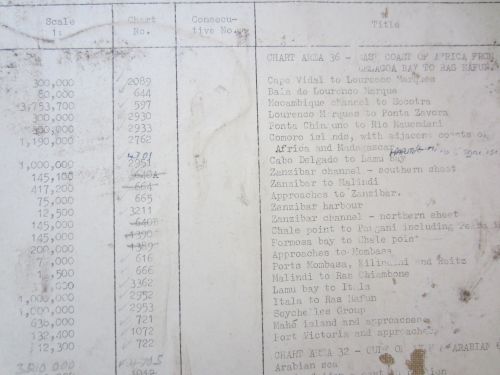
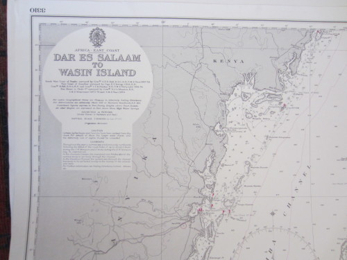
Admiralty Chart Folio 236 of the East Coast of Africa, from Delagoa Bay to Ras Hafun, Gulf of Aden, Madagascar, Chagos Archipelago, Mauritius. There are 25 maps in the folio. Scales of maps vary.
Published by the Photographic Department, Admiralty, London. 1950's to 1960's.
Measurement: Approx 71 x 102 cm (some are slightly bigger).
Condition: They are in very good condition. One has a bit of moth damage.
Price is for all 25 maps. If you'd like to purchase singly, the maps are R350 each.
TITLES:
722: Port Victoria & Approaches. Engraved 1948. This edition 1964.
721: The Seychells Group. Engraved 1875. This edition 1978.
2953: Itala to Ras Hafun. Engraved & published 1953.
2952: Lamu Bay to Itala. Published 1954.
3362: Malindi to Ras Chiambone. Engraved 1957. This edition 1966.
597: Macambique Channal to Socotra. Published 1962.
2089: Cape Vidal to Lourenco Marques. Published 1955.
644: Baia de Lourenco Marques. Engraved 1953. New edition 1964.
2930: Lourenco Marques to Ponta Zavora. Engraved 1956. New edition 1960.
616: Approaches to Mombasa. Published 1960.
2951: Cabo Delgado to Lamu Bay. Published 1963.
3211: Zanzibar Harbour. Published 1959. Some moth damage to map.
665: Approaches to Zanzibar. Published 1959.
2933: Ponta Chinguno to Rio Mauendeni. Published 1961.
3785: Marbat to Maira Island. Engraved 1930. New edition 1952.
2110: Northern Entrance to Mocambique Channel. Published 1963.
758: Cape St Andrew to Antongil Bay. Engraved 1873. New edition 1960.
1116: Baie de Diego-Suarez. Engraved 1893. Published 1963.
759: Baie d'Antongil to Farafangana. Published 1966.
760: Baie d'Ampasilva to Mananjary. Published 1962.
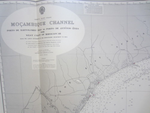
1810: Mocambique Channel. Published 1964.
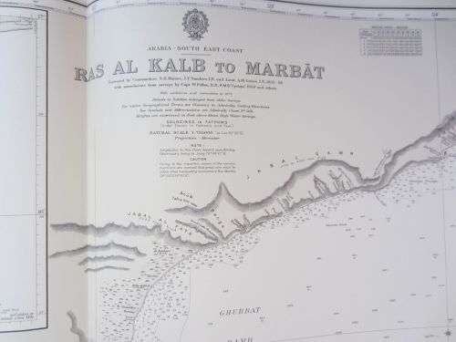
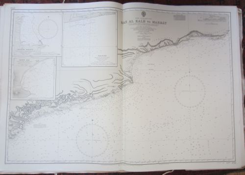
3784: Ras Al Kalb to Marbat. Engraved 1930. New edition 1976.
7: Aden Harbour and Approaches. Published 1966.
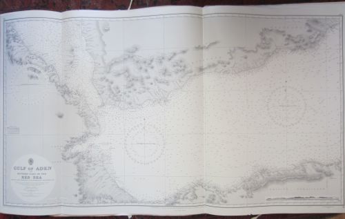
2954: Gulf of Aden - Eastern Portion. Engraved 1949. Edition 1960.
6: Gulf of Aden 1952.