Cape Reconnaissance Maps @ 1907/1914 Set of 38 Digital Maps Digital Download
Digital product
New
Shipping
Free digital delivery
This is a digital product (eg. voucher, product license, service, etc.) and does not require shipping.
The seller will be in contact to deliver this product to you electronically.
Ready to ship in
The seller has indicated that they will usually have this item
ready to ship within 3 business days. Shipping time depends on your delivery address. The most
accurate delivery time will be calculated at checkout, but in
general, the following shipping times apply:
Standard Delivery
| Main centres: | 1-3 business days |
| Regional areas: | 3-4 business days |
| Remote areas: | 3-5 business days |
Returns
Get it now, pay later
Seller
Buyer Protection
Product details
Condition
New
Location
South Africa
Area
Africa
Time Period
1900-1950
Type
Political Map
Bob Shop ID
615214624
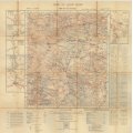
Title: Cape Reconnaissance Maps @ 1907/1914 Set of 38 Digital Maps Digital Download.
Publisher: Colonial Survey for GSGS (Geographical Section, General Staff.)
Format: Vintage Printed Maps that have been scanned and saved as Tiff images.
Printed Size on a large format printer would be as follows:-
Height: @ 90cm.
Width: 75cm.
File Size: Total of 920MB.
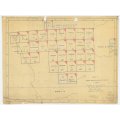
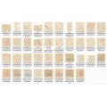
Total Number of Files: 37 Maps plus 1 Grid Map Tiff images @ 20MB to 30MB each.
Info: British War Office published maps surveyed by staff from the Reconnaissance of the Cape of Good Hope. Drawn and Printed by the War Office 1907 and 1914. Specific notes on the maps refer to conditions of the land for military purposes.
There are close ups of towns and river crossings on many of the maps.
Old Place Names and the towns and villages with roads and farms from the early 1900's. Of interest to historians and landowners etc. Covers mainly the Northern Cape and Karoo, from Orange River Mouth down to Bowesdorp on the West Coast. Orange River Mouth to Kimberley along the Northern Border.
Interior from Bowesdorp to Williston across to Nauwpoort / Mount Fletcher. Please consult the grid map in the images for the coverage of the maps in the series.
Great for printing and framing any area required and displaying in the Study or Bar area.
Scale: 1: 250 000
On completion of the order a link will be forwarded to your e-mail address for downloading of the file.
Price: R 475.00 Inc Vat.


