This item has closed with no items sold
View the relisted Item
View the relisted Item
View other items offered by CapeCollectables1041
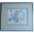
`Europa mit politischer Begranzung der einzelnen Staaten` Map 1826 by Adolf Stieler Framed Print
Secondhand
R595.00
Closed
17 May 24 09:31
Shipping
Standard courier shipping from R30
R30 Standard shipping using one of our trusted couriers applies to most areas in South Africa. Some areas may attract a R30 surcharge. This will be calculated at checkout if applicable.
Check my rate
Check my rate
Free collection from
Kuils River, Cape Town
The seller allows collection for this item and will be in contact with the full collection address once the order is ready.
Ready for collection by Tuesday, 4 June.
Ready to ship in
The seller has indicated that they will usually have this item
ready to ship within 3 business days. Shipping time depends on your delivery address. The most
accurate delivery time will be calculated at checkout, but in
general, the following shipping times apply:
Standard Delivery
| Main centres: | 1-3 business days |
| Regional areas: | 3-4 business days |
| Remote areas: | 3-5 business days |
Returns
Get it now, pay later
Seller
Buyer Protection
Product details
Condition
Secondhand
Location
South Africa
Area
Europe
Time Period
Pre-1800s
Type
Political Map
Bob Shop ID
612634774
Title: "Europa mit politischer Begranzung der einzelnen Staaten" Framed Europe Map 1826 by Adolf Stieler, Print.
First created: Stieler's Atlas Map from 1819, Page Number 12 - this updated Edition Map from 1826.
Publisher: Justus Perthes, Gotha.
Engraver: Johann Carl Ausfeld - "Gestochen Von Joh Carl Ausfeld in Schnepfenthal Bey Gotha" on Bottom Right of Map.
Format: Engraved outline hand colour map by country. Relief shown by hachures.
Type: A Reproduction Print from the Original Atlas.
Height: 50cm.
Width: 57cm.
Info: Of interest is that the map indicates how Europe looked in the 1820's. Europa mit politischer Begranzung der einzelnen Staaten, entw. u. gez. v. Ad. St. 1819. Verbessert Und Neu Gestochen 1826.
On upper right margin = Stielers Hand Atl. No. 12.
Full Title of Atlas: Hand-Atlas uber alle Theile der Erde, nach dem neuesten Zustande und uber das Weltgebaude.
A suitable framed map for the study or library.
Scale: 1 : 18 500 000
Condition: Good, the map is intentionally printed as per how the Original map looks with the browning and foxing - it is exactly how the original now looks. The colour and overall look of the map is still very appealing. The map border mount also has some aging signs at bottom right.
Framed, silver aluminium metal in glass.
Price: R 595.00 Inc Vat.
