This item has closed 1 buyer bought 1 item
View other items offered by gregsact1874

Similar products

R30 shipping
1921 Map of Africa, Excellent condition, Original Poates Map
R395
R30 shipping
Original 1984 South West Africa Road Map A1 size
R400
R30 shipping
ORIGINAL 1856 MAP: Java according to van de Velde drawn by August Petermann. Engraved by Swanston.
R1,250
R30 shipping
1895 Map of Southern Africa - Excellent Condition, Original Times Map
R645
1769 SOUTH AFRICA ORIGINAL MAP. Isaak Tirion. Kaart van Het Zuidelykste Gedeelte van Afrika...

1769 SOUTH AFRICA ORIGINAL MAP. Isaak Tirion. Kaart van Het Zuidelykste Gedeelte van Afrika...

Secondhand
R2,950.00
Closed 27 Jun 19 20:41
Shipping
Standard courier shipping from R30
R30 Standard shipping using one of our trusted couriers applies to most areas in South Africa. Some areas may attract a R30 surcharge. This will be calculated at checkout if applicable.
Check my rate
Free collection from Newlands, Cape Town
The seller allows collection for this item and will be in contact with the full collection address once the order is ready. Ready for collection by Monday, 10 June.
Ready to ship in
The seller has indicated that they will usually have this item ready to ship within 3 business days. Shipping time depends on your delivery address. The most accurate delivery time will be calculated at checkout, but in general, the following shipping times apply:
 
Standard Delivery
Main centres:  1-3 business days
Regional areas: 3-4 business days
Remote areas: 3-5 business days
Get it now, pay later
Buyer Protection

Product details

Condition
Secondhand
Location
South Africa
Customer ratings:
Bob Shop ID
418652758

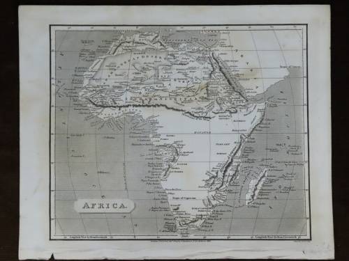
Frame is 59 cm x 57 cm. All in excellent condition and ready to hang on your wall. Map is 33.5 cm by 37 cm and is definitely the 1769 original, professionally framed. Postnet to Postnet is R99.

 TIRION (ISAAK) Kaart van het Zuidelykste Gedeelte van Afrika of het land der Hottentotten, double-page engraved map, part hand-coloured, 335 x 370mm.,Amsterdam,, printed 1769


Fine map of Africa, south of the Tropic of Capricorn filled with information, particularly on the Dutch settlements in the vicinity of Cape Town. The coastline from Cape Agulhas to the east is a bit distorted and the interior features are largely conjectural with the fictitious city of Vigitimagna located. Numerous tribes are shown, often with interesting descriptions (in Dutch). The Kobonas are noted as being cannibals and the Heusaquas are "used in the struggle against the lions."

More from this seller

View all
R30 shipping
Gerbrand van Heerden. Perlemoen Sea Shell. Original oil on canvas, signed . Huge.
R34,500
R30 shipping
1779 Swiss Full Leather 3 Volume Set. Tree Calf Leather. Beautiful. Trembley. Instructions d`un pere
R995
R30 shipping
Solid Sterling Silver Heart Pendant and Fine Necklace marked 925 Italy
R245
R30 shipping
Sandile Sibiya. Huge Original Oil of Zulu Huts. Framed. Signed.
R690

Customer ratings: 1 ratings

Excellent buy and service - thank you so much
09 Jul 2019