This auction has been won.
View other items offered by 19 Century Living437
Leading
henkson657 1 × R1,000.00
11 May 14:27

Similar products

Free shipping
1859 Canada West And Part Of Canada East by J. W. Lowry
R4,999.99
25% OFF
Blaeu Map of Southern Africa 1640, original genuine antique
R9,000.00 R12,000.00
Antique 1768 map Carte Du Canal De Mozambique. Ref. MP-12
R3,750.00
1955 Shell Road Map of Southern Africa Folded Map Section 2
R295.00
1780 - Bonne 'Carte Du Canal de Mozambique' east and west coasts of Southern Africa and Mozambique
Sold

1780 - Bonne 'Carte Du Canal de Mozambique' east and west coasts of Southern Africa and Mozambique

1 was available / secondhand
R50.00 minimum increment
R1,000.00
Shipping
R35.00 Standard shipping using one of our trusted couriers applies to most areas in South Africa. Some areas may attract a R30.00 surcharge. This will be calculated at checkout if applicable.
Check my rate
The seller has indicated that they will usually have this item ready to ship within 3 business days. Shipping time depends on your delivery address. The most accurate delivery time will be calculated at checkout, but in general, the following shipping times apply:
 
Standard Delivery
Main centres:  1-3 business days
Regional areas: 3-4 business days
Remote areas: 3-5 business days
Buyer protection

Product details

Condition
Secondhand
Location
South Africa
Customer ratings:
Bob Shop ID
145589277

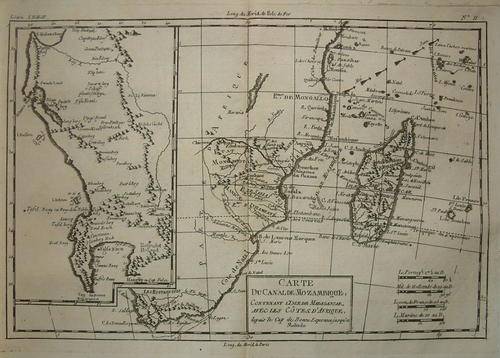
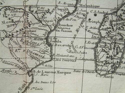
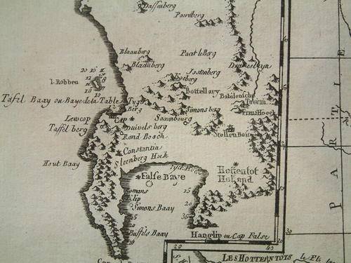
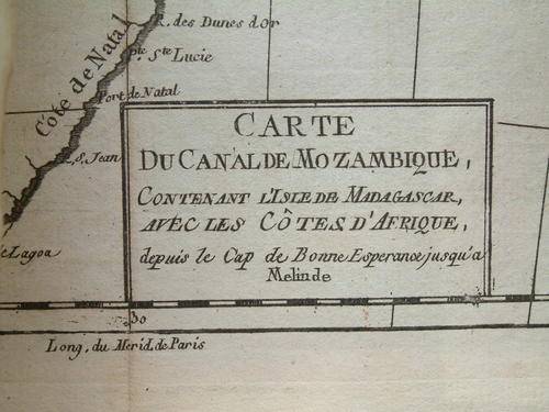
1780 - Bonne 'Carte Du Canal de Mozambique' showing the east and west coasts of Southern Africa and Mozambique

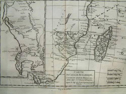
Rigobert Bonne (1727-1795), a prominent French Cartographer of the 18th Century, became the Royal Cartographer to the French King. Although he prepared a large number of Maritime charts, he is best known for the smaller maps (as the one above) he prepared for 'Raynals Atlas de Toutes Les Parties Connues du Globe Terrestre', published in 1780. Unusual for the time, his maps were relatively plain, in black and white, without the usual embellishments associated with that period. Plain they may be, but, they were very detailed.

The medium is a copperplate engraving on a fairly heavy wove paper and the actual image measures 31.5cm x 21.0 cm, the actual paper measuring 40.0cm x 26.5cm There is a centre fold line (as issued) and the text is in French.
All in all, the map, dating back to 1780, remains in very good condition with some slight staining to the top right and left corners of the paper but not of the map itself. The back of the map is blank.
Credits go to
 
Rigobert Bonne (cartographer), Andre (engraver), Abbe Raynal (author) from Atlas de toutes les parties connues du globe terrestre, dressé (Paris, 1780)


This is a genuine antique. Please remember the classification of an 'antique' is that it should be 100 years old, OR MORE. There are many articles being offered as 'antiques' when, clearly, they are not.

Price R1000.00
Post R35.00
 
Terms: We offer a strict three-day approval period from the date the parcel reaches you. Refunds/credits are based on the cost of the article, NOT including delivery charges. Please advise us within this period whether you would like to return any article for a refund/credit. Although we pride ourselves in our packing, the buyer remains responsible for loss, non-arrival or damage to goods being sent to, or returned.


Recently viewed

See more
Lichtenburg souvenir spoon
R25.00
MALE USB TO 30 PIN IPAD CABLE
R215.95
TTP Women Round Toe Wedge Heel Loafers JSF126
R339.00
Midnight Oil - Diesel And Dust (1992)
R50.00

Customer ratings: 1 ratings

Great service and fast follow up !
02 Jun 2014