This auction has closed with no winners.
View the relisted Item
View the relisted Item
View other items offered by Decades2284

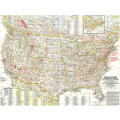
1958 National Parks Map Monuments and Shrines of USA and Canada. National Geographic. 63x43cm
0 was
available
/ secondhand
R155.00
Shipping
Standard courier shipping from R30
R30 Standard shipping using one of our trusted couriers applies to most areas in South Africa. Some areas may attract a R30 surcharge. This will be calculated at checkout if applicable.
Check my rate
Check my rate
Free collection from
Rooi-Els, Rooi-Els
The seller allows collection for this item and will be in contact with the full collection address once the order is ready.
Ready for collection by Friday, 14 June.
Ready to ship in
The seller has indicated that they will usually have this item
ready to ship within 5 business days. Shipping time depends on your delivery address. The most
accurate delivery time will be calculated at checkout, but in
general, the following shipping times apply:
Standard Delivery
| Main centres: | 1-3 business days |
| Regional areas: | 3-4 business days |
| Remote areas: | 3-5 business days |
Get it now, pay later
Seller
Buyer Protection
Product details
Condition
Secondhand
Location
South Africa
Area
The Americas
Time Period
Post-1950
Product code
WM015
Bob Shop ID
614613959
This map lets you discover the abundance and diversity of the lands, forests, memorials, and battle sites administered by the National Park Service. Includes Canadian parks with an inset map of New Brunswick, Nova Scotia, and Prince Edward Island. Published in May 1958 as half of a twomap presentation on national parks.
PLEASE NOTE:
ITEMS CAN STILL BE COMBINED. IF YOU NEED ITEMS FROM DIFFERENT ORDERS TO BE COMBINED UNDER ONE SHIPPING, PLEASE SELECT THE "FREE COLLECTION" OPTION ON EVERY ORDER TILL YOUR READY FOR ME TO SHIP, THEN YOU CAN SELECT THE SHIPPING OPTION ON THE LAST ORDER.
WITH THE NEW BOPSHOP CHANGES THIS WOULD BE THE ONLY WAY TO MAKE IT POSSIBLE TO COMBINE ITEMS.
WHEN YOU SELECT THE SHIPPING OPTION, I WILL HAVE TO GO AHEAD AND SHIP THAT SPECIFIC ORDER WITHIN 3 DAYS AS BOBSHOP NOW MONITORS THE DAYS IT TAKES TO SHIP AND THE SELLER WILL HAVE AN EXTRA DEDUCTION FOR SHIPPING IF THEY DON'T COMPLY. TRUST THIS IS IN ORDER. FEEL FREE TO ASK QUESTIONS AT ANY TIME.
Thank you for your support.