This item has closed 2 buyers bought 2 items

Similar products

The Times atlas of the world - Compact edition
R35.00
Columbus World Travel Atlas 11th Edition
R100.00
Japan - COLLINS
R80.00
Heinemann New Zealand Atlas 1993 Edition.
R275.00
2018 Collins Big Road Atlas Britain (Paperback, New edition)
Sold

2018 Collins Big Road Atlas Britain (Paperback, New edition)

10 were available / new
Indicative market price: R273.00
R215.00
21% off
Shipping
R35.00 Standard shipping using one of our trusted couriers applies to most areas in South Africa. Some areas may attract a R30.00 surcharge. This will be calculated at checkout if applicable.
Check my rate
The seller has indicated that they will usually have this item ready to ship within 3 business days. Shipping time depends on your delivery address. The most accurate delivery time will be calculated at checkout, but in general, the following shipping times apply:
 
Standard Delivery
Main centres:  1-3 business days
Regional areas: 3-4 business days
Remote areas: 3-5 business days
Seller
Buyer protection
Get it now, pay later

Product details

Condition
New
Location
South Africa
Product code
JPFF-4258-G530
Bob Shop ID
288261693
2018 Collins Big Road Atlas Britain (Paperback, New edition) picture

This item is sold brand new. It is ordered on demand from our supplier and is usually dispatched within 7 - 12 working days


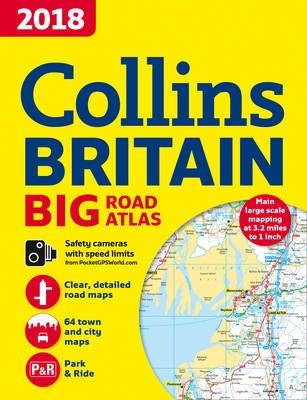
The ultimate 3.2 miles to 1 inch scale large format paperback road atlas of Britain for 2018, featuring Collins' popular and well established road mapping, and designed for exceptional clarity and ease of use. The atlas also includes a wide range of urban area maps at even larger scale and 64 detailed town centre street plans. The mapping shows speed limits at speed camera locations. This fully updated road atlas covers the whole of Britain with each scale of mapping colour-coded for ease of use. The smallest scale maps are great for long distance route planning and the street plans help you locate your final destination. The atlas includes: * Easy to use, clear road maps at a scale of 3.2 miles to 1 inch of England, Wales and Southern Scotland. Northern Scotland is shown at 5 miles to 1 inch. * Route planning section including maps at a scale of 15.8 miles to 1 inch (1:1,000,000) for long distance route planning, motorway services information and a handy distance calculator. * 22 urban area approach maps at 1 mile to 1 inch which clearly show the best routes through and into the busiest built-up areas. * 64 street maps focused on town centres showing places of interest, car park locations and one-way streets. * Fully updated fixed speed camera sites with average speed camera locations clearly highlighted. All speed cameras show the speed limit. * M25 orbital map. * Information about restricted motorway junctions. * Park & Ride locations shown, ideal when visiting towns and cities. * Over 30 categories of places of interest including castles, theme parks, sports venues, universities, mountain bike trails and surfing beaches. * Full postcodes for the top 1000 places of interest - ideal for use alongside satnav systems.

Features

SummaryThe ultimate 3.2 miles to 1 inch scale large format paperback road atlas of Britain for 2018, featuring Collins' popular and well established road mapping...
AuthorCollins Maps
PublisherCollins
Release date20170615
Pages159
ISBN0-00-821460-3
ISBN 13978-0-00-821460-9

Recently viewed

See more
Free shipping
DragonBall Z Gameboy Color
R2,300.00
MARVEL COMICS - THE MIGHTY THOR - IST ISSUE VOL. 1 NO. 433 1991
R79.90
DURAN DURAN Rio (Remastered with Extra Tracks) CD
R189.00
Spider-Man #15
R89.00