Similar products


| Main centres: | 1-3 business days |
| Regional areas: | 3-4 business days |
| Remote areas: | 3-5 business days |
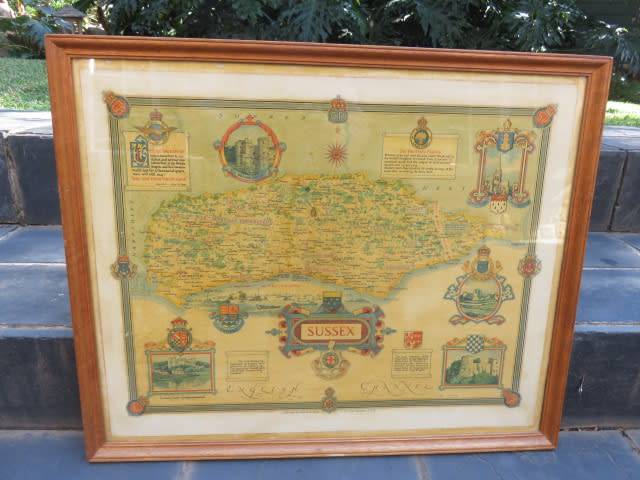
A New Map of the County of Sussex, divided into Rapes and Hundreds – London printed for Charles Smith, 172 The Strand January 6th 1801

Charles Smith, in 1800, established a London firm of engravers, stationers and mapsellers. In 1827 through to 1852, the firm was known and traded as Charles Smith & Son. He was appointed Mapseller to the Prince of Wales (and subsequently the King) by 1809. He died in 1854 and was buried at Highgate Cemetery aged eighty six. His son William Smith inherited the 'copper plates and implements for making globes' and his grandson, Guildford Smith 1838-1917, son of William, was engaged in the business from at least 1861 and elected FRGS in 1865. The business continued on into the twentieth century, being taken over by the George Philip firm in 1916.
His first county atlas, Smith’s New English Atlas was issued in 15 parts with an index and title page. Maps in parts 1 to 14 are dated 1801, the maps in part 15 and title page are dated 1804.


The map of Sussex (offered above) is a copper engraved map with hand colouring, showing the Market Towns with distances from London in miles. Parks and Gentlemen’s Houses, Turnpike Roads, Navigable Canals, rivers, Churches are all shown, the description in the atlas read ’hand coloured & compass rose (fleur de lys marks north) & scale line & lat and long scales & coast form lines & rivers & relief & hill hachuring & beacons (near Pitt) & woods & forests & trees & parks & county & hundreds & settlements & roads & turnpike roads & distances from London & canals & table of symbols & table of hundreds’


A rape was a traditional sub-division of the county of Sussex in England. Their origin is unknown, but they appear to predate the Norman Conquest. Each rape was split into several hundreds. The rapes may derive from the system of fortifications devised by Alfred the Great in the late ninth century to defeat the Vikings. Alternatively, King Alfred's system may in turn have its roots in an earlier age. If so, the Sussex Rapes, like the Kentish Lathes, go back to the dawn of English history when their main function would have been to provide food rents and military manpower to the king. Possibly surviving from the Romano-British era, or perhaps representing the shires of the kingdom of Sussex, the Sussex rapes each had a headquarters in the developed south where the lord's hall, court, demesne lands, principal church and peasant holdings were located whereas to the north there were smaller dependent settlements in the marsh, woodland and heath.
 The map measures approximately 46cm x 50 cm and is mounted in an older frame. Although it is in an overall good condition, there are some small holes to the top and bottom of the map, possibly due to moth