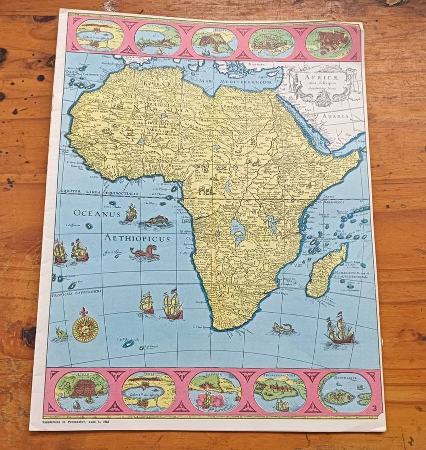
Africa Map Atlas of 1968 with Maps of Africa from 1660, 1884, 1939 and 1968!
Secondhand
1 was available
R30.00
minimum increment
R31.00
Shipping
R65.00 Standard shipping applies to orders under R100.00, in most areas in South Africa. R35.00 Standard shipping applies to orders over R100.00. Some areas may attract a surcharge surcharge. This will be calculated at checkout if applicable. Check my rate
R65.00 pickup point shipping applies to orders under R100.00, in most areas in South Africa. R35.00 pickup point shipping applies to orders over R100.00. There are various locker and counter collection points across South Africa. View locations
The seller has indicated that they will usually have this item
ready to ship within 7 business days.
Shipping time depends on your delivery address.
The most accurate delivery time will be calculated at checkout,
but in general, the following shipping times apply:
Africa Map Atlas of 1968 with Maps of Africa from 1660, 1884, 1939 and 1968!
ON AUCTION IS A HISTORICAL 1968 MAP ATLAS OF AFRICA. PUBLISHED AS A PERSONALITY MAGAZINE SUPPLEMENT ON 6 JUNE 1968. SIZE 25CM WIDE AND 33CM HIGH.
THIS MAP IS A WINDOW INTO THE PAST THAT ALLOWS YOU TO EXPLORE AFRICA AS IT WAS OVER CENTURIES. IT CONTAINS MAPS OF AFRICA FROM 1660, 1884, 1939 AND 1968. IT ALSO CONTAIN A WORLD MAP OF 1968 AND VARIOUS GEOGRAPHICAL AND DEMOGRAPHIC MAPS OF AFRICA.
THE FIRST AFRICA MAP OF 1660 BY BLAEU IS ONE OF THE MOST DECORATIVE AND POPULAR OF ALL EARLY MAPS OF AFRICA, FROM THE GOLDEN AGE OF DUTCH MAPMAKING. First issued in 1630, the map was reprinted many times between 1631 and 1667. The maps and atlases of the Blaeu family business, carried on after Willems death by sons Cornelis and Joan, marked the epitome of fine engraving and coloring, elaborate cartouches and pictorial detail, and fine calligraphythe most magnificent work of its type ever produced.
In the format called carte à figures, this appealing map contains oval views of, presumably, the major cities and trading ports of Africa at the time: Tangier and Ceuta (Morocco), Tunis (Tunisia), Alexandria and Cairo (Egypt), Mozambique (seaport of Mozambique), Elmina (Ghana, site of the largest and most spectacular castle in Africa built by the Portuguese), and Grand Canary (Canary Islands).
THE INTERIOR IS DECORATED WITH EXOTIC ANIMALS (LIONS, ELEPHANTS, OSTRICHES), WHICH WERE (AND STILL ARE) A MAJOR SOURCE OF FASCINATION FOR THE PUBLIC. THE NILE (TODAYS WHITE NILE) IS INACCURATELY SHOWN FLOWING FROM THE PTOLEMAIC LAKES OF ZAIRE AND ZAFLAN. FLYING FISH AND STRANGE SEA CREATURES CAVORT IN THE OCEANS, AND THE SAILING SHIPS ALL BEAR DUTCH FLAGS.
Probably the most interesting cartographic feature is the identification of specific large territories or kingdoms, which have been outlined in color, including a huge Abyssinia (Ethiopia) and Monomotapa (all of southern Africa). But these seem to reflect a European sense of nationhoodsomething presumed and projected upon a virtually unexplored canvasmore than the actual experience of traders and explorers, who would continue to report on hundreds of smaller ethnic enclaves and political fiefdoms during the next 250 years.
THE NEXT MAP OF AFRICA FROM 1884 depict the continent just before the Berlin Conference, which officially began in November 1884 and finalized the partition of Africa among European powers. THIS MAP REFLECT THE STATES OF COLONIAL PRESENCE BEFORE THE FULL "SCRAMBLE FOR AFRICA" WAS FORMALIZED. Some areas were already colonized (like British South Africa or French Algeria), but many others were still governed by local rulers or had only partial, negotiated, or contested European presence. This map still show the presence of independent African kingdoms, empires, and other states that would later be dissolved by the Berlin Conference. Examples include the Zulu Kingdom and the Boer Republics, though the latter's independence was contested and eventually lost.
THE AFRICA MAP OF 1939 STILL SHOW AFRICA DIVIDED INTO COLONIAL CONTROLLED AREAS. Like British controlled Northern Rhodesia (now Zambia) and Southern Rhodesia (now Zimbabwe). It still shows the Belgium Congo and French West Africa.
THE 1968 MAP OF AFRICA SHOWS A MAP WHERE SOME AFRICAN COUNTRIES HAS ACHIEVED INDEPENDENCE LIKE RHODESIA WHO DECLARED INDEPENDENCE FROM BRITAIN IN 1965.
AN INTERESTING NOTE TO THE 1968 WORLD MAP IS BANGLADESH WHICH STILL NOT EXIST AND CEYLON WHICH STILL HAS NOT BECOME SRI LANKA. Bangladesh became the separate Pakistani province of East Pakistan after 1947. An Independence war followed and the nation of Bangladesh was declared on March 26, 1971, followed by the surrender of Pakistani forces on December 16, 1971. "Ceylon" is the former name of the island nation now known as Sri Lanka. The country was officially named Ceylon until 1972 and was a British colony before gaining independence in 1948. The name "Ceylon" is still widely used in the context of "Ceylon tea," which was first cultivated during the colonial era.
THIS 1968 AFRICA MAP ATLAS IS A MUST-HAVE FOR ANYONE INTERESTED IN THE HISTORY AND EVOLUTION OF THE WORLD. NOTE I HAVE ANOTHER 1970 POSTER MAP OF THE WORLD AND A 1969 POSTER MAP OF AFRICA ALSO ON AUCTION THIS WEEK.
DIMENSIONS: 25CM WIDE 33CM HIGH
CONDITION: FEW PAPER CURLS AT EDGES. COLOURS BRIGHT. GOOD VINTAGE CONDITION..
WILLEM BLAEU (1571-1638): Willem Janszoon Blaeu (1571-1638) was a prominent Dutch geographer and publisher. Blaeu set up shop in Amsterdam. In 1635, he released his atlas in Latin, Theatrum Orbis Terranum, ("Theatre of the Lands of the World"), sive (or), Atlas Novus (new atlas). German, Dutch and French versions of this atlas were published through about 1667. Willem died in 1638. He had two sons, Cornelis (1610-1648) and Joan (1596-1673). Later in life, Joan would modify and greatly expand his fathers Atlas Novus eventually releasing his masterpiece, the Atlas Major between 1662 and 1672 which reached 12 volumes. The Blaeus' atlas production came to an abrupt end with the fire in their workshop and the resulting destruction of many printing plates in 1672.
PLEASE HAVE A LOOK AT MY OTHER ITEMS LISTED. I HAVE 2 OTHER VINTAGE MAPS ON AUCTION THIS WEEK. YOU CAN CLICK ON MY NAME OR COPY THE URL UNDERNEATH AND PASTE INTO GOOGLE AND IT WILL TAKE YOU DIRECTLY TO ALL MY LISTINGS THIS WEEK. NOTE ALL MY AUCTIONS END AT 22H30 SO IT IS ADVISABLE TO PUT IN AN AUTOMATIC BID (HIGHEST PRICE YOU ARE WILLING TO PAY) EARLY. HTTPS://WWW.BIDORBUY.CO.ZA/SELLER/3685641/ERNREX1545