Bains Railways Map of South Africa Digital Map Download Bains Railways Map of South Africa Digital Map Download Bains Railways Map of South Africa Digital Map Download Bains Railways Map of South Africa Digital Map Download Bains Railways Map of South Africa Digital Map Download Bains Railways Map of South Africa Digital Map Download Bains Railways Map of South Africa Digital Map Download Bains Railways Map of South Africa Digital Map Download
Bains Railways Map of South Africa Digital Map Download Bains Railways Map of South Africa Digital Map Download Bains Railways Map of South Africa Digital Map Download Bains Railways Map of South Africa Digital Map Download
Bains Railways Map of South Africa Digital Map Download
+4

Bains Railways Map of South Africa Digital Map Download

Digital product
Secondhand 1 available
R295.00
Shipping
This is a digital product (eg. voucher, product license, service, etc.) and does not require shipping. The seller will be in contact to deliver this product to you electronically.
The seller has indicated that they will usually have this item ready to ship within 3 business days. Shipping time depends on your delivery address. The most accurate delivery time will be calculated at checkout, but in general, the following shipping times apply:
 
Standard Delivery
Main centres:  1-3 business days
Regional areas: 3-4 business days
Remote areas: 3-5 business days
Seller
Buyer protection
Get it now, pay later

Product details

Condition
Secondhand
Location
South Africa
Area
Africa
Time Period
1900-1950
Type
Political Map
Bob Shop ID
654212039

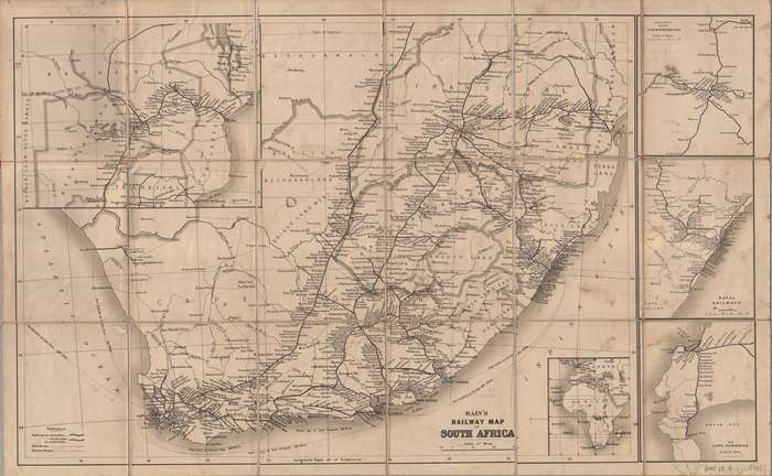
Title: Bains Railways Map of South Africa Digital Map Download.
Cartographer and Publisher: John G Bains .
Format: Vintage Printed Maps that have been scanned and saved as Tiff images.
File Size: Total of 4.3MB JPG and 24MB JP2 file
Total Number of Files: 2 x File JPG, same map fdifferent file types.
Info: 
Map of South Africa indicating which railway lines were in operation, which were under construction and which had been authorised. 
The map also shows cities, towns, roads and rivers, the mail routes and steamer routes (with distances in miles).
Insets: 
Railways around Johannesburg, Scale 1:950 400
Natal railways, Scale 1:4 828 032
The Cape Peninsula, 1:402 336
Africa Untitled inset map showing the northern extension of the railway lines from Mafeking to Bulawayo, Salisbury, Mazoe and Umtali in Rhodesia, and to Beira in Portuguese East Africa.
Format: Digital files transferred via WeTransfer - A download Link will be forwarded on completion of order.
Price: R 295.00 Inc Vat.


Add to cart

Recently viewed

See more
Aquamarine - Faceted Rectangle Shape - 0.255cts
New
R160.00 No bids
19% OFF
Grey Stone Large Ceramic Table Lamp
New
R1,433.00 R1,769.00
JUST JINGER Just Jinger CD [Gx18]
Secondhand
R45.00
Emjay Nipple 1 In. (25 Mm)
New
R20.69

Similar products

South Africa Relief Map Digital Download For Vinyl Decal Print for Vehicles
New
R125.00
South Africa 52 x District Municipality Maps Digital Download
New
R395.00
1880 Map of South Africa, Excellent Condition, Original Map Major Railways
Secondhand
R445.00
South Africa Relief Map Digital Download For Vinyl Decal Print for Vehicles
New
R125.00