This item has closed 1 buyer bought 1 item
View other items offered by CapeCollectables1049

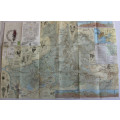
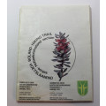
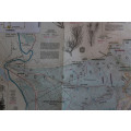
Cape Nature Conservation Boland Hiking Trail HH Section 1994 Folded Map
Secondhand
R95.00
Closed
27 Jan 23 11:39
Shipping
Standard courier shipping from R60
R60 Standard shipping applies to orders under R100, in most areas in South Africa. R30 Standard shipping applies to orders over R100. Some areas may attract a R30 surcharge. This will be calculated at checkout if applicable.
Check my rate
Check my rate
Free collection from
Somerset West, Cape Town
The seller allows collection for this item and will be in contact with the full collection address once the order is ready.
Ready for collection by Wednesday, 12 June.
Ready to ship in
The seller has indicated that they will usually have this item
ready to ship within 3 business days. Shipping time depends on your delivery address. The most
accurate delivery time will be calculated at checkout, but in
general, the following shipping times apply:
Standard Delivery
| Main centres: | 1-3 business days |
| Regional areas: | 3-4 business days |
| Remote areas: | 3-5 business days |
Returns
Get it now, pay later
Seller
Buyer Protection
Product details
Condition
Secondhand
Location
South Africa
Area
Africa
Time Period
Post-1950
Type
Physical Map
Customer ratings:
Bob Shop ID
576448434