This item has closed 2 buyers bought 4 items

Similar products

50% OFF
Geography Basic Facts (Collins Gem) - SOFT COVER
R35 R69.95
R30 shipping
Collins Illustrated Checklist. Birds of Southern Africa. Ber Van Perlo.
R115
R30 shipping
The Last Rain Forests: A World Conservation Atlas edited by Mark Collins
R120
R30 shipping
The Great Apes Between Two Worlds ~ Michael Nichols Deluxe Edition | National Geographic Book
R150

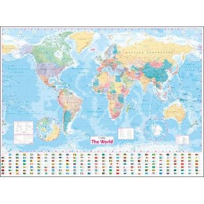
Collins World Wall Laminated Map (Sheet map, flat, New edition)

New
Indicative market price: R302
R246.00 19% OFF
Closed 27 Jan 20 03:08
Shipping
Standard courier shipping from R30
R30 Standard shipping using one of our trusted couriers applies to most areas in South Africa. Some areas may attract a R30 surcharge. This will be calculated at checkout if applicable.
Check my rate
Ready to ship in
The seller has indicated that they will usually have this item ready to ship within 3 business days. Shipping time depends on your delivery address. The most accurate delivery time will be calculated at checkout, but in general, the following shipping times apply:
 
Standard Delivery
Main centres:  1-3 business days
Regional areas: 3-4 business days
Remote areas: 3-5 business days
Get it now, pay later
Seller
Buyer Protection

Product details

Condition
New
Location
South Africa
Product code
JNSK-4024-G590
Bob Shop ID
443077355
Collins World Wall Laminated Map (Sheet map, flat, New edition) picture

This item is sold brand new. It is ordered on demand from our supplier and is usually dispatched within 7 - 11 working days


Fully updated world map to include the latest political changes. Contains politically coloured mapping showing each country and their capital city, major roads, railways and cities and towns clearly. Also included are national flags, key statistics for every country and inset maps of the polar regions. This laminated (on front side only) map is printed on high quality paper and comes rolled in a plastic tube - ideal as a poster for any classroom, bedroom or office wall. Area of coverage: All of the world, centred on the Greenwich Meridian, and including maps of the North and South Pole regions. Scale: 1:22 000 000; 1 cm to 220 km; 1 inch to 347 miles Size: 1015 x 1380 mm (40 x 54 inches) Other versions available: Paper flat map in tube (ISBN 978-0-00-821158-5).

Features

SummaryFully updated world map to include the latest political changes. Contains politically coloured mapping showing each country and their capital city, major roads...
AuthorCollins Maps
PublisherCollins
Release date20170428
ISBN0-00-821156-6
ISBN 13978-0-00-821156-1

Recently viewed

R30 shipping
Power HD Storm35 High Pressure Brushless Servo 35KG Metal Gears for RC Vehicles Car... (COLOR1: RED)
R2,099