Fairest Cape Map of Cape Peninsula 2000 Printed Map Laminated Fairest Cape Map of Cape Peninsula 2000 Printed Map Laminated Fairest Cape Map of Cape Peninsula 2000 Printed Map Laminated Fairest Cape Map of Cape Peninsula 2000 Printed Map Laminated Fairest Cape Map of Cape Peninsula 2000 Printed Map Laminated Fairest Cape Map of Cape Peninsula 2000 Printed Map Laminated Fairest Cape Map of Cape Peninsula 2000 Printed Map Laminated Fairest Cape Map of Cape Peninsula 2000 Printed Map Laminated
Fairest Cape Map of Cape Peninsula 2000 Printed Map Laminated Fairest Cape Map of Cape Peninsula 2000 Printed Map Laminated Fairest Cape Map of Cape Peninsula 2000 Printed Map Laminated Fairest Cape Map of Cape Peninsula 2000 Printed Map Laminated
Fairest Cape Map of Cape Peninsula 2000 Printed Map Laminated
+4

Fairest Cape Map of Cape Peninsula 2000 Printed Map Laminated

1 available / new
Only 1 left – grab it before it’s gone!
R465.00
Shipping
Free shipping is available from CapeCollectables for all orders above R1,500.00, using one of our trusted couriers.
Check my rate
The seller allows collection for this item. Buyers will receive the collection address and time once the order is ready.
The seller has indicated that they will usually have this item ready to ship within 3 business days. Shipping time depends on your delivery address. The most accurate delivery time will be calculated at checkout, but in general, the following shipping times apply:
 
Standard Delivery
Main centres:  1-3 business days
Regional areas: 3-4 business days
Remote areas: 3-5 business days
Seller
Buyer protection
Get it now, pay later

Product details

Condition
New
Location
South Africa
Area
Africa
Time Period
Post-1950
Type
Political Map
Product code
8327182
Bob Shop ID
631110980

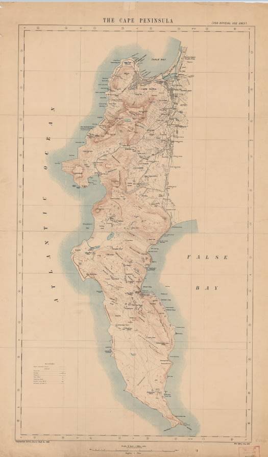
Title: Fairest Cape Map of Cape Peninsula 2000 Printed Map Laminated.
Publisher: NGI Topographical Map.
Height: 84cm.
Width: 70cm.
Format: Colour Printed on Poster Paper, and Laminated.
Info: Informative easy to read map of the Cape Peninsula, circa 2000.
Cape Peninsula, False Bay and Table Bay, Cape Town, Hangklip, Robben Island, Paarl South, Stellenbosch.
Edition: First Edition Topographical Map 2000.
Scale: 1: 100 000
Condition: Very Good - New.
Price: R 465.00 Inc Vat.


Add to cart

Recently viewed

See more
Union of SA - 1942-44 SACC102a 1/- BROWN(``BURSTING SHELL`` VARIETY) VFU CV R2700
R550.00
FUSE F/BLOW GLASS 5A 5x20 - CONQUER UFE5A *A*
R2.68
50% OFF
Cuphead (PS4) Fast shipping
R649.00 R1,299.00
Enslaved: Odyssey to the West (XBOX 360)
R189.99

Similar products

Fairest Cape Map of Cape Peninsula 2000 Printed Map
R335.00
Map of Cape Colony 1901 Wall Map, Reproduction Print
R295.00
Reproduction Printed Map of the Cape Peninsula - Issued by The War Office 1909.
R295.00
Cape Peninsula 1934 - 80th Anniversary Surveys and Mapping, Set of 4 Maps, Reproduction Prints
R550.00