The unit is Garmin's top of the range GPS and are even very scarce to find in South Africa. This unit does absolutely everything when it comes to navigating the outdoors. This Garmin Colorado 400C retails new for well over R6000 in stores and is well worth every cent. The GPS is still boxed / as new condition and was only used once on a two day hiking trip. The GPS comes supplied with a carabiner clip, usb cable, instruction manuals and well as Garmin's Trip and Waypoint Software CD.
I have also preloaded onto the GPS, 2009 South African Topographic and Street Maps, so the unit is ready for use. These maps even show you where the rivers / streams are located in the wild to allow you to plan adequately throughout you hiking excursions! This is everything you would ever want in a GPS and the best that Garmin has to offer!
The package includes:
- Garmin Colorado 400C GPS Unit (Boxed and as new)
- Garmin Carabiner Clip
- Garmin USB Cable
- Garmin Instruction Manuals
- Garmin Trip and Waypoint Manager Software CD
Payment and shipping:- The winning bidder must complete payment (EFT Deposit) within 24 hours of winning the auction.
- No collections (Shipping will be R150 counter-counter insured - Overnight)
- Please alow 48 hours for dispatch of shipping


More information and specifications:
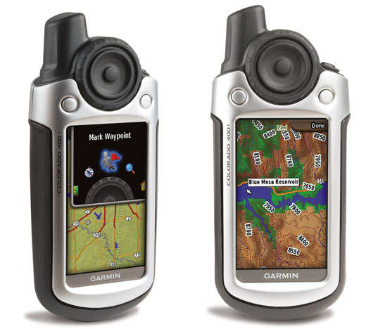
Gear up and explore the backcountry with the all-terrain Colorado 400. Packed with features, it includes a built-in basemap, high-sensitivity receiver, barometric altimeter, electronic compass, SD™ card slot, color display, picture viewer and more. Even exchange tracks, waypoints, routes and geocaches wirelessly between similar units. When the going gets tough, Colorado leads the way.
Explore More
Colorado 400 comes with a built-in worldwide basemap with shaded relief and accepts SD cards for all your outdoor activities on land or water. Just take your pick from Garmin’s preprogrammed SD cards including street maps, topographic maps, coastal charts or inland lake data. The card slot is located inside the waterproof battery compartment, so you don't have to worry about getting it wet.
Share Wirelessly
With Colorado 400 you can share your waypoints, tracks, routes and geocaches wirelessly with other Colorado users. Now you can send your favorite hike to your buddy to enjoy or the location of a cache to find. Sharing data is easy. Just select “send” to transfer your information to other Colorado units.
Rock on. Find Fun
Intuitive and fun, Colorado features a Rock ‘n Roller® input wheel for easy one-handed operation and supports Geocaching.com GPX files for downloading geocaches and detail straight to your unit. Customize Colorado's interface based on your favorite activity. Even show off photos of your excursions with its picture viewer. Slim, lightweight and waterproof, Colorado is the perfect companion for all your outdoor pursuits.
Keep Your Fix
With its high-sensitivity, WAAS-enabled GPS receiver, Colorado 300 locates your position quickly and precisely and maintains its GPS location even in heavy cover and deep canyons. The advantage is clear — whether you’re in deep woods or just near tall buildings and trees, you can count on Colorado to help you find your way when you need it the most.
Get Your Bearings
Colorado 400 has a built-in electronic compass that provides bearing information even while you're standing still, and its barometric altimeter tracks changes in pressure to pinpoint your precise altitude. You can even use the altimeter to plot barometric pressure over time, which can help you keep an eye on changing weather conditions.
Get Connected
You've been busy exploring and now you want to store and analyze your activities. With a simple connection to your computer and to the Internet, you can get a detailed analysis of your activities and send tracks to your outdoor device using Garmin Connect™. This one-stop site offers an activity table and allows you to view your activities on a map using Google™ Earth. Explore other routes uploaded from over 12 million customers and share your experiences on Twitter® and Facebook®. Getting started is easy, so get out there, explore, and share.