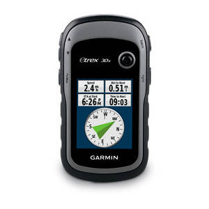
Handheld GPS with 3-axis Compass, Enhanced Display and Preloaded Mapping
- 2.2 inch crystal clear colour display- Pre-loaded with OSM Recreational Map of Africa- High-sensitivity, GPS receiver with HotFix and GLONASS support- 4GB internal memory. Expand further with a microSD card (not included).- 3-axis compass and barometric altimeter- Worldwide basemap with shaded reliefeTrex 30x is our upgraded version of the popular eTrex 30, with enhanced screen resolution and extended internal memory to hold more maps. The preloaded OSM Recreational Map of Africa supports and enhances a range of outdoor activities, such as hiking, geocaching, mountaineering and fishing. eTrex 30x has superior features compared to eTrex 30, while maintaining its ease-of-use, affordability and legendary durability.
See the Way
eTrex 30x has an enhanced 2.2 inch, 65K colour, sunlight-readable display. Durable and water-resistant, eTrex 30x is built to withstand the elements. It has an upgraded interface yet retains its toughness to withstand dust, dirt, humidity or water.
New Tools for Your Trek
The in-built 3-axis tilt-compensated electronic compass keeps your bearings even when you're standing still or not holding it level. Also added is a barometric altimeter that tracks changes in pressure to pinpoint your altitude. Use it to plot barometric pressure over time to help you keep an eye on changing weather conditions.
Go Anywhere
Fit your eTrex 30x just about anywhere, using an array of compatible mounts. Use the auto mount capability and City Navigator NT maps for turn-by-turn driving directions, or the rugged mount for your bike or quad. You can even mount to a boat for fishing or sailing trips.
Go Global
The eTrex series can track both GPS and GLONASS satellites simultaneously - it has the ability to lock on to 24 more satellites than using just GPS. What's more, the time it takes to "lock on" to a position is (on average) 20% faster than using GPS alone. With its high-sensitivity GPS receiver and HotFix satellite prediction, eTrex locates your position quickly and precisely and maintains its GPS location even in heavy cover and deep valleys.
Preloaded Recreational Map of Africa
eTrex 30x comes preloaded with the **Recreational Map of Africa - Topo Light. This map enables you to orienteer and reference any outdoor or recreational activity in 58 African countries, compiled using the community-generated *OpenStreetMap (OSM) database.- Includes non-routable street and off-road networks, international boundaries, waterways, natural features,land use areas, historical sites, airport structures, buildings and more.- Displays thousands of points of interest, including shops; restaurants and bars; car parks; schools anduniversities; and accommodations.- Plan outdoor activities, organize your data and share your adventures with others through ourfree downloadable trip-planning software,
BaseCamp.Use the microSD card slot to load additional advanced maps - like
Topo maps,
BlueChart g2 marine maps or
City Navigator NT maps. eTrex 20x also supports
BirdsEye Satellite Imagery (subscription required) to download and integrate with your maps.* Garmin OpenStreetMap is based on OSM mapping data, map quality depends heavily on local mapping coverage, Garmin cannot guarantee the quality and completeness of mapping data.** No Warranty ~ Garmin OpenStreetMap products are provided to you "as is", and you agree to use it at your own risk. Garmin and its licensors, including the licensors, service providers, channel partners and suppliers, and affiliated companies of Garmin and its licensors, make no guarantees, representations or warranties of any kind, express or implied, arising by law or otherwise, including but not limited to, content, quality, accuracy, completeness, effectiveness, reliability, merchantability, fitness for a particular purpose, usefulness, use or results to be obtained from the Garmin OpenStreetMap products, or that the content or server will be uninterrupted or error-free. The Garmin OpenStreetMap products are intended to be used only as a supplementary travel aid and must not be used for any purpose requiring precise measurement of direction, distance, location or topography. Garmin makes no warranty as to the accuracy or completeness of the map data in the OpenStreetMap products.
