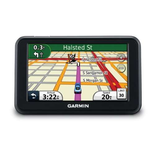
GARMIN NUVI 40

Warranty
LOADED WITH LATEST SA STREET MAPS 2014 SOUTHERN AFRICA
ALSO LOADED WITH LATEST POI WHICH INCLUDE FIXED & SPEED CAMS
POSTAGE R100
COMES COMPLETE WITH
CAR CHARGER AND ORIGINAL MOUNT AND BRACKET

Garmin Nuvi 40 GPS
Providing a complete navigation solution and an easy-to-use user interface, the nüvi 40 navigates you safely to your required destination. Designed to make navigation easy, simply enter an address and premium features including Lane Assist with Junction View, help you make all the right turns. The nüvi 40 is supplied with preloaded Garmin City Navigator Southern Africa NT maps
Simply select your destination and leave the navigating to the nüvi 40. The device features a 4.3" (10.9 cm) colour touchscreen and provides accurate, turn-by-turn directions that speak street names.
Get Turn-by-turn Directions
The nüvi 40’s intuitive interface greets you with 2 simple choices: “Where To?” and “View Map”. Touch the screen to easily look up addresses and services and to be guided to your destination with voice- prompted, turn-by-turn directions that speak street names. The nüvi 40’s speed limit indicator shows you how fast you can go on most major roads and with its “Where Am I?” emergency locator, you always know your location.
Know the Lane Before It’s Too Late
Now there’s no more guessing which lane you need to be in to make an upcoming turn. Lane Assist with Junction View guides you to the correct lane for an approaching turn or exit, making unfamiliar intersections and exits easy to navigate. It displays generic images of upcoming road signs and junctions on your route along with arrows that indicate the proper lane for navigation.
Easy to use 4.3” (10.9 cm) colour touchscreen display.
With Garmin’s Where Am I? Emergency locator, you always know your location.
Simply tap the vehicle icon on the map screen to get your exact latitude and longitude coordinates.
The nearest address, intersection, closest hospitals, police and petrol stations are also displayed.
HotFix predicts satellite locations for faster acquisition at star ÂÂÂÂup.
It works by giving the restarted GPS device a head start by knowing where to start looking for GPS satellites.
A Point of interest, or POI, is a specific point location that specifies the latitude and longitude of the POI.
A name or description for the POI is usually included.
Other information such as a description of the POI and a telephone number may also be attached.
Drive safely and legally with Garmin’s unique Cyclops safety cameras which are built in.
Reliable and accurate alerts, over speed warning and speed limit information
Lane Assist guides you to the correct lane for an approaching turn or exit, making unfamiliar intersections easy to navigate.
Junction View* displays generic images of upcoming road signs and junctions on your route along with arrows that indicate the proper lane for navigation.
Expand the memory for additional data such as photographs or maps through the microSD card slot.
Get voice ÂÂÂÂprompted, turn by ÂÂÂÂturn directions with spoken street names for extra route awareness with no need to look at the screen