This item has closed with no items sold
View the relisted Item
View the relisted Item
View other items offered by CapeCollectables1041

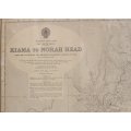
Kiamah to Norah Head Australia Hydrographic Chart 1957
Secondhand
R575.00
Closed
1 Jun 24 12:16
Shipping
Standard courier shipping from R30
R30 Standard shipping using one of our trusted couriers applies to most areas in South Africa. Some areas may attract a R30 surcharge. This will be calculated at checkout if applicable.
Check my rate
Check my rate
Free collection from
Kuils River, Cape Town
The seller allows collection for this item and will be in contact with the full collection address once the order is ready.
Ready for collection by Wednesday, 5 June.
Ready to ship in
The seller has indicated that they will usually have this item
ready to ship within 3 business days. Shipping time depends on your delivery address. The most
accurate delivery time will be calculated at checkout, but in
general, the following shipping times apply:
Standard Delivery
| Main centres: | 1-3 business days |
| Regional areas: | 3-4 business days |
| Remote areas: | 3-5 business days |
Returns
Get it now, pay later
Seller
Buyer Protection
Product details
Condition
Secondhand
Location
South Africa
Area
Australasia
Time Period
Post-1950
Type
Nautical Charts
Bob Shop ID
614086895
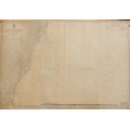
Title: Kiamah to Norah Head Australia Hydrographic Chart 1957.
Publisher: Published at the Admiralty, 27th September 1957. With Corrections to 1956. Crown Copyright Reserved.
Cartographer: Rear Admiral K St B Collins OBE DSC Hydrographer.
Scale: 1 to 300 000.
Production Date: September 1957.
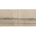
Info: Hydrographic Chart Number 1025. Australia East Coast - New South Wales. From the Australian and British Governments Surveys to 1955. From Lake Macquarie in the North, with the Hawkesbury river mouth, Sydney Harbour, Botany Bay and south to Lake Illawarra on the southern NSW coast.
Format: Original release Print from 1957.
Condition: Fair, with some edges deteriorating, some wear and tear on folds. With course plotting marks previously on the chart.
The Chart has one fold down the centre but has been stored rolled up.
Price: R 575.00 Inc Vat.
This would be a wonderful antique style map, suitable for framing and placed in a Nautical theme bar or office.
![]()