This item has closed with no items sold
View the relisted Item
View other items offered by CapeCollectables1320

Similar products

Rand McNally Map of Africa 1904 Digital Download
New
R195.00
Cape Southern Districts @ 1880/1900 Set of 14 Digital Maps Digital Download
New
R350.00
Antique Map of British India by John Tallis 1851
Secondhand
R1,195.00
National Geographic Africa 1962 Poster Map Digital Download
New
R295.00
Map of Africa by John Tallis 1880 Digital Download Map of Africa by John Tallis 1880 Digital Download Map of Africa by John Tallis 1880 Digital Download Map of Africa by John Tallis 1880 Digital Download Map of Africa by John Tallis 1880 Digital Download Map of Africa by John Tallis 1880 Digital Download
Map of Africa by John Tallis 1880 Digital Download Map of Africa by John Tallis 1880 Digital Download Map of Africa by John Tallis 1880 Digital Download Map of Africa by John Tallis 1880 Digital Download
Map of Africa by John Tallis 1880 Digital Download
+2
Closed

Map of Africa by John Tallis 1880 Digital Download

Digital product
New 1 was available
R295.00
Shipping
This is a digital product (eg. voucher, product license, service, etc.) and does not require shipping. The seller will be in contact to deliver this product to you electronically.
The seller has indicated that they will usually have this item ready to ship within 3 business days. Shipping time depends on your delivery address. The most accurate delivery time will be calculated at checkout, but in general, the following shipping times apply:
 
Standard Delivery
Main centres:  1-3 business days
Regional areas: 3-4 business days
Remote areas: 3-5 business days
Buyer protection
Get it now, pay later

Product details

Condition
New
Location
South Africa
Area
Africa
Time Period
1800s
Type
Political Map
Bob Shop ID
614086754

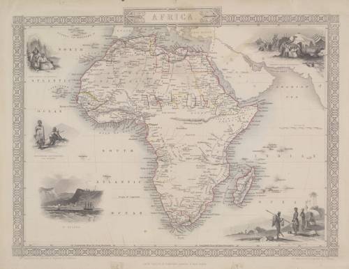
Title: Map of Africa by John Tallis 1880 Digital Download.
Map By: John Tallis.
Drawn and Engraved By: J Rapkin.
Publisher: John Tallis & Company, London & New York.
Year Published: 1880.
File Type and Size:  JP2 File 18MB and JPG 38MB File Images.
Printed Size: Can be printed in A3 size.
Info: Five engraved vignettes are seen, an Arab family of Algeria, Bosjeman Hottentots, a view of St. Helena, a Bedouin Arabs' encampment and Korranna Hottentots. "The illustrations were drawn by J. Marchant and engraved by J.H. Kernot. 
The map was drawn and engraved by J. Rapkin"
Condition: Digital Download.
Price: R 295.00.00 Inc Vat.


Please Note: 
On completion of the order a link will be forwarded to your e-mail address for downloading of the file.
Large image files require sufficient processing power and memory capabilities to render efficiently on the screen. 
JP2 Files can be viewed with Irfan View or GIMP, free Open Source Graphic Viewers and editors.
Prior to printing please ensure that the printer has sufficient RAM for processing the image


Recently viewed

See more
131Pc Thread Repair Tool Set (Foam Tray) AMPRO T46069
New
R1,953.28
Gas Stove Igniter
New
R289.43
1965 50cent x3 and 1cent Coin Lot
Secondhand
R100.00 No bids
Free shipping
9% OFF
6 Seater Protea with 190 x 110cm Rectangular Table
New
R29,900.00 R32,900.00