This item has closed 1 buyer bought 1 item
View other items offered by CapeCollectables1255

Similar products

Eastern Cape Provincial Map - Printed Map
R195.00
Northern Cape Provincial Map - Printed Map
R195.00
Northern Cape Provincial Map - Printed and Laminated
R395.00
Map of Cape Colony 1901 Wall Map, Reproduction Print
R295.00
Map Of Cape Town 1884 Poster Print Map Of Cape Town 1884 Poster Print Map Of Cape Town 1884 Poster Print Map Of Cape Town 1884 Poster Print Map Of Cape Town 1884 Poster Print Map Of Cape Town 1884 Poster Print
Map Of Cape Town 1884 Poster Print Map Of Cape Town 1884 Poster Print Map Of Cape Town 1884 Poster Print Map Of Cape Town 1884 Poster Print
Map Of Cape Town 1884 Poster Print
+2
Sold

Map Of Cape Town 1884 Poster Print

1 was available / secondhand
R295.00
Shipping
Free shipping is available from CapeCollectables for all orders above R1,500.00, using one of our trusted couriers.
Check my rate
The seller allows collection for this item. Buyers will receive the collection address and time once the order is ready.
The seller has indicated that they will usually have this item ready to ship within 3 business days. Shipping time depends on your delivery address. The most accurate delivery time will be calculated at checkout, but in general, the following shipping times apply:
 
Standard Delivery
Main centres:  1-3 business days
Regional areas: 3-4 business days
Remote areas: 3-5 business days
Buyer protection
Returns
Money-Back Guarantee: 7 Days: Refund if returned, excluding Postage.
Get it now, pay later

Product details

Condition
Secondhand
Location
South Africa
Area
Africa
Time Period
1800s
Type
Other
Customer ratings:
Bob Shop ID
417476237

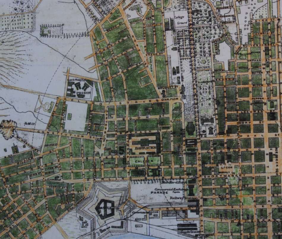
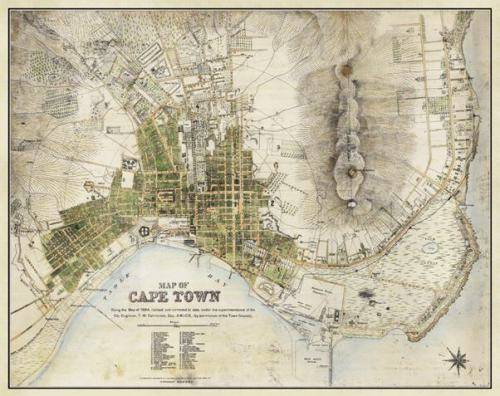
Title: Map Of Cape Town 1884, revised, Poster Print.
Publisher: W A Richards and Sons, Castle St, Cape Town.
Scale: 4 inch = 1/2 mile.
Year: 1884 revised to date 1891.
Format:  Scanned and Printed on Poster Paper.
Height: 53cm.
Width: 66cm.
Info: Striking map of Cape Town, South Africa, by W.A. Richards & Sons, circa 1884.
The map is oriented with south southwest at the top. Some of the major features of the map include:
Cape Town Station
The Sea Point Railway
The tramway from the Amsterdam Battery to the Standard Bank in Adderly Street.
The Cape Town Station used to stand where one now finds the Golden Acre Shopping center, while the Goods Station was where today's Cape Town Station is located.
Late 19th-century Cape Town was a city in rapid transition, enjoying a sudden economic boom after the discovery of diamond fields to the north of it. In this 1884 map of the capital of the British Cape Colony—which is usually oriented with southwest at the top—the grid plan of the original Dutch settlement is still clearly visible.
The shoreline as it was prior to land reclamation which began in the 1930's and 1940's shows the Castle in relation to the coast when originally constructed.
Map Type: Reproduction Print.
Condition: Excellent.

Price: R 295.00 Inc Vat.

Recently viewed

See more
Modern and Striking Silver and Onyx/Black Glass Pendant
R850.00
Switzerland & Germany stamps on prepaid Swiss surcharged post card airmail express Northeim to Worb
R99.00 No bids
CD - Demi Lovato - Demi
R49.00
RELIEF-THROAT LOZ 24 ORIGINAL
R47.96

Customer ratings: 1 ratings

Fantastic to deal with and brilliant service! Many thanks for going the extra mile.
13 Jun 2019