


Mapping South Africa ~ Andrew Duminy | A Historical Survey of South African Maps and Charts
Check my rate
| Main centres: | 1-3 business days |
| Regional areas: | 3-4 business days |
| Remote areas: | 3-5 business days |
Product details
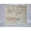
Mapping South Africa: A Historical Survey of South African Maps and Charts
Andrew Duminy
Binding: Hard cover with dust jacket 134 pages
Book Condition: Very good condition
Edition: Jacana First Edition 2011
Filled with beautiful reproductions of some 85 maps, this is the first survey of the fascinating story of maps and mapmaking in the subcontinent. Beginning with the Portuguese voyages of exploration in the late 15th century, it explores the attempts of the Dutch and the British to chart and lay claim to the vast and expanding landscape of the Cape Colony. Subsequent chapters investigate the maps of the Eastern Cape, where a series of frontier wars led to an outpouring of cartography, as well as the maps of colonial Natal and the Boer Republics of the Transvaal and Free State, where cartography was driven, conversely, by the dictates of colonization and land exploitation. Drawing upon several scholarly articles, this history reveals an appreciation of the close relation between science, exploration, and cartography and gives due prominence to the role played by individuals as well as institutions in producing maps of increasing accuracy and detail.
Follow the link below to view our other listings: