This item has closed 1 buyer bought 1 item
View other items offered by Booktown Richmond1174

Similar products

British Antarctic Terra Nova Expedition 1910-1913 Maps Of The Exploration Framed
Secondhand
R395.00
The Men Who Mapped the World (with removable maps)
New
R450.00
Cape Reconnaissance Maps @ 1907/1914 Set of 38 Digital Maps Digital Download
New
R475.00
The Men Who Mapped the World (with removable maps)
New
R450.00
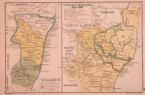
Maps: Natal 1824-75 & N. Natal & Zululand 1845-1910
Sold

Maps: Natal 1824-75 & N. Natal & Zululand 1845-1910

Secondhand 1 was available
R290.00
Shipping
R35.00 Standard shipping using one of our trusted couriers applies to most areas in South Africa. Some areas may attract a R30.00 surcharge. This will be calculated at checkout if applicable.
Check my rate
The seller has indicated that they will usually have this item ready to ship within 3 business days. Shipping time depends on your delivery address. The most accurate delivery time will be calculated at checkout, but in general, the following shipping times apply:
 
Standard Delivery
Main centres:  1-3 business days
Regional areas: 3-4 business days
Remote areas: 3-5 business days
Buyer protection
Get it now, pay later

Product details

Condition
Secondhand
Location
South Africa
Customer ratings:
Product code
JD186
Bob Shop ID
340248578
Colour Maps measuring 14.5x23cm (Natal 1824-75) and 21x23.5cm (N. Natal & Zululand 1845-1910), in Very Good condition. From: Historic Atlas of South Africa, Humphrey Milford, Oxford University Press, 1922. Insured Postage (RSA) is included in the price.

Recently viewed

See more
Nail-Free Pole Bracket Shower Holders Retainers Mounts Racks Home White
New
R279.00
Car Carbon Fiber Gear Shift Knob Cover Sticker for- A5 A4L Q5L Gear Head Cap for RHD
New
R765.00
For Xiaomi Redmi K50 Ultra / 12T / 12T Pro Blade Series TPU + Titanium Alloy Phone Case(Black Gold)
New
R209.00
1Pc White For iPhone 14 Phone Case Phone Cover
New
R88.00 No bids

Customer ratings: 1 ratings

Thank you!
29 May 2018