This item has closed 1 buyer bought 1 item
View other items offered by Booktown Richmond1174

Similar products

The Men Who Mapped the World (with removable maps)
New
R450.00
Cape Reconnaissance Maps @ 1907/1914 Set of 38 Digital Maps 16GB USB Flash Drive
New
R545.00
40% OFF
Maps Garden Route x 2
Secondhand
R150.00 R250.00
The Men Who Mapped the World (with removable maps)
New
R450.00
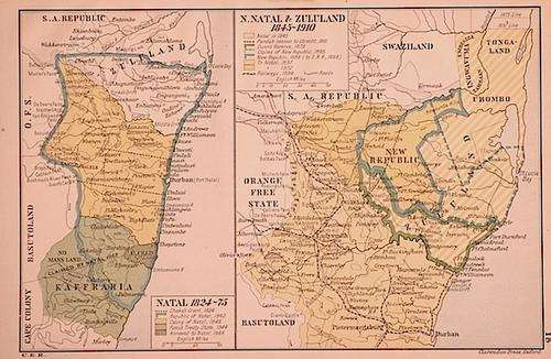
Maps: Natal 1824-75 & N. Natal & Zululand 1845-1910
Sold

Maps: Natal 1824-75 & N. Natal & Zululand 1845-1910

Secondhand 1 was available
R290.00
Shipping
R35.00 Standard shipping using one of our trusted couriers applies to most areas in South Africa. Some areas may attract a R30.00 surcharge. This will be calculated at checkout if applicable.
Check my rate
The seller has indicated that they will usually have this item ready to ship within 3 business days. Shipping time depends on your delivery address. The most accurate delivery time will be calculated at checkout, but in general, the following shipping times apply:
 
Standard Delivery
Main centres:  1-3 business days
Regional areas: 3-4 business days
Remote areas: 3-5 business days
Buyer protection
Get it now, pay later

Product details

Condition
Secondhand
Location
South Africa
Customer ratings:
Product code
JD186
Bob Shop ID
340248578
Colour Maps measuring 14.5x23cm (Natal 1824-75) and 21x23.5cm (N. Natal & Zululand 1845-1910), in Very Good condition. From: Historic Atlas of South Africa, Humphrey Milford, Oxford University Press, 1922. Insured Postage (RSA) is included in the price.

Recently viewed

See more
Meilan X6 Smart Auto Brake Rear Light Rechargeable Bicycle Tail Light(Black)
New
R428.00
Resident Evil Extinction (DVD)
Secondhand
R15.00
Eureka MustHaves Clear Measuring Tape 19mm x 5m
New
R198.00
African Magnesite egg
Secondhand
R99.00

Customer ratings: 1 ratings

Thank you!
29 May 2018