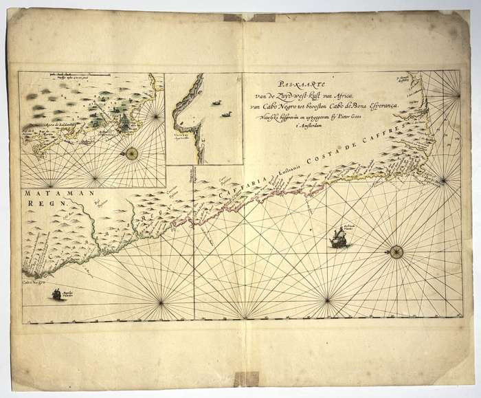
Copperplate engraving with original hand colour. Language: Dutch. This sea chart, drawn and published by the prominent Amsterdam cartographer Pieter Goos, presents the southern segment of the west coast of Africa, extending from Cabo Negro (modern-day Angola-Namibia border) southward to Cabo de Bona Esperanca (Cape of Good Hope). The Pas-Kaarte van de Zinder-west-kust van Africa is among the more technically precise and regionally specific nautical charts in Goos's Zee-Atlas ofte Water-Wereld, underscoring the Dutch Republic's growing maritime interests along the southwestern coast of Africa during the second half of the 17th century. Condition: Good. Short tears to margins and some chipping to edges. Professionally repaired with Japanese tissue. Wide upper and lower margins with tape marks. Geographic Scope and Detail: The chart traces a long and largely unbroken coastline, covering key coastal features such as: The coasts of Angola and Namibia, including Benguela, Lobito, and Luanda, which were strategic ports in Dutch and Portuguese colonial rivalry. Numerous bays, headlands, shoals, and reefs, all crucial for navigation in a region known for treacherous waters. The Orange River mouth and the uncharted Namaqualand coast. Cape Agulhas and the Cape of Good Hope, marking the navigational gateway between the Atlantic and Indian Oceans. Place names are rendered in Dutch, often transliterated from Portuguese or local origins. Inlets and rivers are marked, though the inland regions are left empty, as was standard practice for marine charts of the time. Navigational Features: The map is crisscrossed by an intricate network of rhumb lines emanating from two compass roses, indicating wind directions for open-sea navigation. Soundings, anchorages, danger zones, and currents are recorded with notable accuracy for the period. Scale bars are included in Dutch, Spanish, and English nautical miles, aiding use by an international maritime audience. The cartographic style follows the "plane chart" projection, a simplified approach intended for practical maritime use rather than geographic accuracy. 17600
Publisher: Pieter Goos
Date Published: circa 1666
Publication Place: Amsterdam
Condition: Good.