This auction has closed with no winners.
View the relisted Item
View other items offered by doug40741594

Similar products

Poole map plate showing enlarged view of Poole harbour
Closed

Poole map plate showing enlarged view of Poole harbour

Secondhand 1 was available
R20.00 minimum increment
R135.00
R145.00
Shipping
R35.00 Standard shipping using one of our trusted couriers applies to most areas in South Africa. Some areas may attract a R30.00 surcharge. This will be calculated at checkout if applicable.
Check my rate
The seller allows collection for this item. Buyers will receive the collection address and time once the order is ready.
The seller has indicated that they will usually have this item ready to ship within 4 business days. Shipping time depends on your delivery address. The most accurate delivery time will be calculated at checkout, but in general, the following shipping times apply:
 
Standard Delivery
Main centres:  1-3 business days
Regional areas: 3-4 business days
Remote areas: 3-5 business days
Buyer protection
Get it now, pay later

Product details

Condition
Secondhand
Location
South Africa
Origin
Poole
Type
Plates & Bowls
Product code
332
Bob Shop ID
658776944

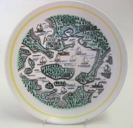
A white earthenware map plate showing Poole harbour (enlarged view). This is one of a series of six map plates produced by Poole in the 1960s and 1970s. The design was drawn by Tony Morris (1968-78). The backstamp is Poole mark no. 59 (1973-4). No chips or cracks. Diameter 230 mm.

To view the other items I'm selling, click here: http://www.bidorbuy.co.za/seller/445258/doug4074