This is a digital product (eg. voucher, product license, service, etc.) and does not require shipping.
The seller will be in contact to deliver this product to you electronically.
The seller has indicated that they will usually have this item
ready to ship within 3 business days.
Shipping time depends on your delivery address.
The most accurate delivery time will be calculated at checkout,
but in general, the following shipping times apply:
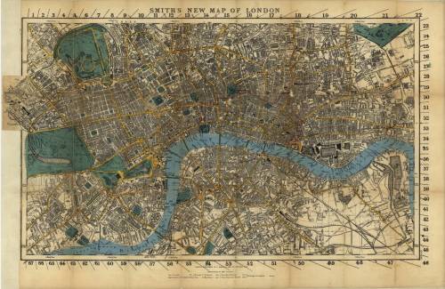
Title: Smith's New Map of London 1860 Digital Download. Map By: Charles Smith. Publisher: C Smith & Son. Year Published: 1860. Scale: 3.7 inches to 1 x mile. File Type and Size: 118MB TIFF File Image, aslo supplied in PDF Format. Printed Size: Can be printed in A2, A1 or up to A0 Size. Info: "By 1800, the population of London had reached one million, making it the world's largest city. By the end of the 1900s, its population was approaching five million. The rapid growth of cities such as London created new challenges for mapmakers, including confused street names, the constant appearance of new streets and buildings, and the problem of aligning the trigonometric measurement of streets with actual measurement. Growth also created new demand for maps -- from businesses, insurance companies, government agencies, and tourists. This 1860 map by C. Smith & Son shows a London much expanded from its original core along the Thames River to encompass new boroughs in all directions. The different divisions of the city are color-coded. Charles Smith was a map and globe seller, established around 1800 at 172 Strand, who specialized in maps and atlases of England. Smith's business later was taken over by his son, and continued until well into the 20th century." World Digital Library. Format: Digital files transferred via WeTransfer - A download Link will be forwarded on completion of order. Price: R 195.00.00 Inc Vat.
Please Note: Large image files require sufficient processing power and memory capabilities to render efficiently on the screen. JP2 Files can be viewed with Irfan View or GIMP, free Open Source Graphic Viewers and editors.