Swartberg & Klein-Karoo Touring Map: 4th Edition Swartberg & Klein-Karoo Touring Map: 4th Edition

Swartberg & Klein-Karoo Touring Map: 4th Edition

New 1 available
Indicative market price: R300.00
Only 1 left – grab it before it’s gone!
R290.00
Shipping
R35.00 Standard shipping using one of our trusted couriers applies to most areas in South Africa. Some areas may attract a R30.00 surcharge. This will be calculated at checkout if applicable.
Check my rate
There are various locker and counter collection points across South Africa.
View locations
The seller has indicated that they will usually have this item ready to ship within 2 business days. Shipping time depends on your delivery address. The most accurate delivery time will be calculated at checkout, but in general, the following shipping times apply:
 
Standard Delivery
Main centres:  1-3 business days
Regional areas: 3-4 business days
Remote areas: 3-5 business days
Seller
Buyer protection
Get it now, pay later

Product details

Condition
New
Location
South Africa
Product code
9781776322787
Bob Shop ID
611775634

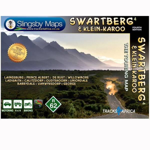
The mountains and the Klein-Karoo provide a playground for tourists there are ostrich farms, wildlife parks, the Cango caves, endless fascination for explorers, and a richness of facilities and activities that's as good as you could find anywhere.

This is the first detailed map ever produced for the area; may it guide you on many an exciting journey of discovery.

This double-sided, full-relief map covers, at a scale of 1:160 000, the entire Swartberg mountain range from west to east. North of the mountains the towns of Laingsburg, Prince Albert, and Willowmore are included; through the Klein-Karoo the major towns are Ladismith, Calitzdorp, Oudtshoorn, and De Rust.

The southern boundary of the map is defined by the northern slopes of the Langeberg-Outeniqua range, with towns Barrydale, Vanwyksdorp, George, and Uniondale.

All roads from National Highways to minor gravel roads are shown; the many classifications that indicate the quality of each road help you plan your route
No less than 28 mountain passes are shown all are public roads!
Distances are clearly shown; comprehensive 4 x 4 information
GPS coordinates in DD MM SS format are provided for every road junction
All tourism facilities and accommodation establishments are shown in the out-of-town areas; there are insets of the major towns

The map links to our maps of the Baviaanskloof, the Garden Route, Overberg and the Tankwa-Karoo

Add to cart

Recently viewed

See more
Night Light Humidifier With 7 LED Light Mode
New
R459.00
SA RECCE REGT. PENCIL SKETCH BY L. GREWER STEENKAMP AND SIGNED BY MAJ. F.W. LOOTSand COL. JAN BREYTE
Secondhand
R80.00 No bids
21% OFF
PA14 Solar String Camp Light
New
R299.99 R379.99
Foundation Maths (6th Edition) - Anthony Croft
Secondhand
R443.45

Similar products

Touring Map of South Africa - John Hall
New
R90.00
DIE KLEIN KAROO - N LEGKAART Teks: Abrraham H. de Vries Fotograaf: Paul Alberts
Secondhand
R390.00
10% OFF
Zimbabwe Traveller's Map (1st Edition)
New
R405.00 R450.00
Touring Map of Mozambique
Secondhand
R70.00