
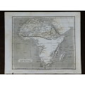
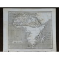
1809 Map of Africa, Great Condition, Original Russel / Stratford Map
Check my rate
| Main centres: | 1-3 business days |
| Regional areas: | 3-4 business days |
| Remote areas: | 3-5 business days |
Product details
Africa
1809 Original Map
Very Good Condition


The map is an original 1809 issue and NOT a reproduction.
It measures 215mm x 262mm in total
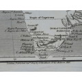
The map is printed in black ink on medium thick paper.The parer is still crisp and responsive to handling, very well preserved overall. There are some age spots and discolouration ion places. Original 1809 map of Africa Published by J Statford as a part of :"The world: or, the present state of the universe. Being a general and complete collection of modern voyages and travels. Selected, arranged, and digested, from the narratives of the latest and most authentic travellers and navigators". This is a copperplate engraving by J Russell. Some of these were issued hand coloured, but this example was issued without that laboursome addition.