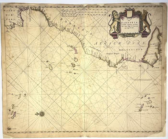
Copperplate engraving, hand coloured. This sea chart by Pieter Goos, De Cust van Barbara, Gualata, Arguyn, en Gene, represents a detailed portion of the northwest coast of Africa, focusing on the Saharan and Mauritanian littoral. It covers the coastline from roughly Cape Bojador (Barbary Coast) southward through Gualata (Walata), Arguin, and Gene (Senegal region)an area of strategic importance to early modern European maritime powers, particularly in the context of trade with West Africa. Published in Goos's Zee-Atlas ofte Water-Wereld, a lavish maritime atlas designed for both practical and commercial use by ship captains and merchants of the Dutch Republic. It is a rare example of early cartographic attention to a region more often passed over in favour of better-known parts of the West African coast. Condition: Good. Short tears to margins and some chipping to edges almost entirely outside the platemark. Professionally repaired with Japanese tissue. Geographic Scope and Detail: Barbara refers to the Barbary Coast, encompassing parts of present-day Western Sahara and southern Morocco. Gualata (Walata) is represented in a coastal context, though the historic city lies inlandsuggesting a confusion or conflation typical of European cartography of the interior during this era. Arguin is prominently marked, including Île d'Arguin, a small island off the Mauritanian coast that was home to a series of trading posts and forts contested by the Portuguese, Dutch, and later the French. Gene likely refers to the Senegalese coast, possibly derived from a local or Portuguese form of the Senegal River. The coastline is delineated with notable attention to bays, shoals, inlets, and river mouths, though inland features are minimal or absenttypical of Dutch sea charts designed primarily for coastal navigation Navigational Features: A network of rhumb lines radiates from a central compass rose, marking the thirty-two points of navigation used by European mariners. The chart includes soundings, hazards, and anchorage points, particularly near the Arguin Bankan area notorious for its shallow waters and shipwrecks. The scale bar is rendered in Dutch, Spanish, and English nautical miles, facilitating international use. Decorative and Symbolic Elements: The title cartouche is elaborately designed with baroque flourishes and maritime iconography. It may include allegorical figures representing Africa or references to local trade, such as gold and gum arabic. A handful of Dutch ships under sail adorn the ocean, emphasising both the cartographic function and Dutch naval presence. Sea monsters or stylised marine life may appear in the open sea areas, blending early modern symbolic art with navigational caution. Historical Context: The northwest African coast was a frontier of early European-African contact. The Dutch West India Company (WIC) established brief but significant control over portions of the coast, including Arguin, in competition with the Portuguese. The region was rich in resources such as gold, slaves, salt, and gum arabic, and served as a stopping point for ships bound further south. Goos's attention to this lesser-charted region reflects the ambitions of Dutch merchants and explorers to expand into under-mapped zones of commercial interest. This map would have been a vital navigational aid for WIC vessels and other European ships operating in the region. 8800
Publisher: Pieter Goos
Date Published: circa 1666
Publication Place: Amsterdam
Condition: Good.