Kaap Goldfields Barberton District Map by S Erskine 1887 Digital Download Kaap Goldfields Barberton District Map by S Erskine 1887 Digital Download Kaap Goldfields Barberton District Map by S Erskine 1887 Digital Download Kaap Goldfields Barberton District Map by S Erskine 1887 Digital Download Kaap Goldfields Barberton District Map by S Erskine 1887 Digital Download Kaap Goldfields Barberton District Map by S Erskine 1887 Digital Download
Kaap Goldfields Barberton District Map by S Erskine 1887 Digital Download Kaap Goldfields Barberton District Map by S Erskine 1887 Digital Download Kaap Goldfields Barberton District Map by S Erskine 1887 Digital Download Kaap Goldfields Barberton District Map by S Erskine 1887 Digital Download
Kaap Goldfields Barberton District Map by S Erskine 1887 Digital Download
+2

Kaap Goldfields Barberton District Map by S Erskine 1887 Digital Download

Digital product
New 1 available
Only 1 left – grab it before it’s gone!
R295.00
Shipping
This is a digital product (eg. voucher, product license, service, etc.) and does not require shipping. The seller will be in contact to deliver this product to you electronically.
The seller has indicated that they will usually have this item ready to ship within 3 business days. Shipping time depends on your delivery address. The most accurate delivery time will be calculated at checkout, but in general, the following shipping times apply:
 
Standard Delivery
Main centres:  1-3 business days
Regional areas: 3-4 business days
Remote areas: 3-5 business days
Seller
Buyer protection
Get it now, pay later

Product details

Condition
New
Location
South Africa
Area
Africa
Time Period
1800s
Type
Other
Product code
8325367
Bob Shop ID
629708112

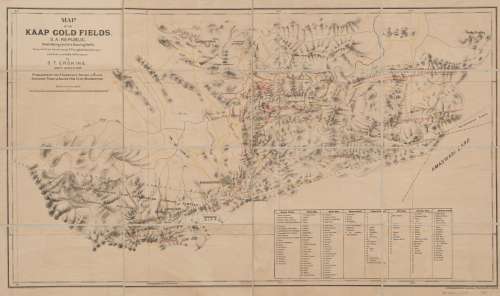
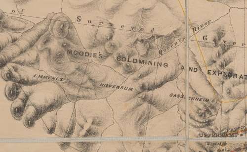
Title: Kaap Goldfields Barberton District Map by S Erskine 1887 Digital Download.
Map By: S.T. Erskine (Government Surveyor), Pizzighelli, R.(Government Surveyor.)
Lithographed By: The Argus Printing Co. Limited.
Publisher: Published by The Transvaal Share & Claim Exchange Trust & Agency Co (Ltd) Barberton.
Year Published: 1887.
Scale: 1 Inch to 1 Mile.
File Type and Size:  JP2 File 39MB and JPG 8.8MB File Images.
Printed Size: Can be printed up to A3 & A2 size.
Info: Map of the Kaap Goldfields S.A. Republic Illustrating the Gold Bearing Reefs.
Compiled from the survey by R. Pizzighelli (Government Surveyor) and best available information by S.T. Erskine Government Surveyor.
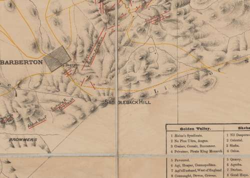
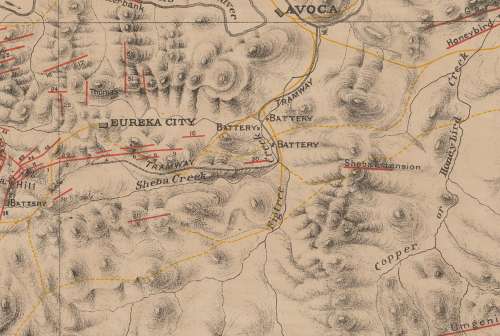
A Map with an Index of Claims and Workings showing Barberton, Jamestown, Eureka City and Avoca, Golden Valley, Sheba Hill, Rimers Creek, Imperial Reef, Lily Reef, Caroline Reef and Heslop's Creek.
The map also shows tramways, rivers, hills and mountains, roads and paths of the area.
Relief shown by shading with a Bar Scale in Miles.
Condition: Digital Download.
Price: R 295.00.00 Inc Vat.


Please Note: 
On completion of the order a link will be forwarded to your e-mail address for downloading of the file.
Large image files require sufficient processing power and memory capabilities to render efficiently on the screen. 
JP2 Files can be viewed with Irfan View or GIMP, free Open Source Graphic Viewers and editors.
Prior to printing please ensure that the printer has sufficient RAM for processing the image.


Add to cart

Recently viewed

See more
PS TO92 ECB 50V 3A 150 300 SML 2SB985
New
R6.60
Rowland Hilder Signed Painter and Illustrator
Secondhand
R450.00
T'Pau – Heart And Soul - 7" Record - Very-Good+ Quality (VG+) (verygoodplus7) (DLB)
Secondhand
R149.00
Potentiometer 10 T W/W Lin 22mm 10 K 2 W 3590 S 2 103 L
New
R117.29

Similar products

Bains Railways Map of South Africa Digital Map Download
Secondhand
R295.00
Deutsche-Sudwesafrika 1913 Map Digital Map Digital Download
New
R295.00
Free State Provincial Map - Digital Download
New
R120.00
Northern Cape Provincial Map - Digital Download
New
R120.00