Colton`s Map Of The United States of America 1849 Digital Download Colton`s Map Of The United States of America 1849 Digital Download Colton`s Map Of The United States of America 1849 Digital Download Colton`s Map Of The United States of America 1849 Digital Download Colton`s Map Of The United States of America 1849 Digital Download Colton`s Map Of The United States of America 1849 Digital Download Colton`s Map Of The United States of America 1849 Digital Download
Colton`s Map Of The United States of America 1849 Digital Download Colton`s Map Of The United States of America 1849 Digital Download Colton`s Map Of The United States of America 1849 Digital Download Colton`s Map Of The United States of America 1849 Digital Download
Colton`s Map Of The United States of America 1849 Digital Download
+3

Colton`s Map Of The United States of America 1849 Digital Download

Digital product
New 1 available
Only 1 left – grab it before it’s gone!
R195.00
Shipping
This is a digital product (eg. voucher, product license, service, etc.) and does not require shipping. The seller will be in contact to deliver this product to you electronically.
The seller has indicated that they will usually have this item ready to ship within 3 business days. Shipping time depends on your delivery address. The most accurate delivery time will be calculated at checkout, but in general, the following shipping times apply:
 
Standard Delivery
Main centres:  1-3 business days
Regional areas: 3-4 business days
Remote areas: 3-5 business days
Seller
Buyer protection
Get it now, pay later

Product details

Condition
New
Location
South Africa
Area
The Americas
Time Period
1800s
Type
Political Map
Product code
8325323
Bob Shop ID
629708068

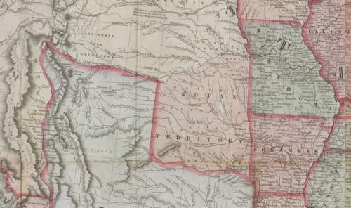
Title: Colton's Map Of The United States of America 1849 Digital Download.
Map By: J H Colton.
Publisher: J H Colton.
Year Published: 1849.
File Type and Size:  JP2 File 111MB and JPG 64MB File Images.
Printed Size: Can be printed up to A2 and A1 / A0 Size.
Info: 
Map of the United States of America, the British Provinces, Mexico, the West Indies and Central America with part of New Granada and Venezuela.
Drawn by Geo. W. Colton.
Engraved by John. M. Atwood.
Border dessigned and engraved by W. S. Barnard.
2 bar scales on map, given in "Statute Miles" and "Geographical Miles" 
The detailed map shows topography, rivers, state boundaries, cities and towns, railroads, roads, canals, ocean routes, etc. 
With a floral border and decorative cartouche with eagle.
Illustrations of ships and descriptive text throughout with an inset of the Atlantic Ocean.
"Entered according to act of Congress in the year 1848 by J.H. Colton in the Clerks Office of the Southern District of New York."
12 pictorial vignettes around the border: Willammette Falls, Oregon // Astoria, Oregon //Saratoga Lake, New York // Valley of the Connecticut from Mt. Holyoke // Bunker Hill Monument Boston, Mass. // Washington Monument New York // Capitol, Washington City // Entrance of a port // Mexicans catching wild cattle // Cathedral, City of Mexico // Pulaski Monument Savannah, Ga. // Pulaski Monument Savannah, Ga. // Battle Monument Baltimore, Md. 
Condition: Digital Download.
Price: R 195.00.00 Inc Vat.


Add to cart

Recently viewed

See more
Japanese Teak Flavor Solid Wood Creative Pear-shaped Dish (pear)
New
R378.00
For Huawei Mate 50 SIM + NM Card Tray (Purple)
New
R145.00
Asg Bersa Thunder 9 Pro 4.5mm Bb Pistol Combo 2
New
R1,670.00
Front Bumper Fog Light Grille Cover For Audi Q3 2013-2015 Right 8U0807682A
New
R1,274.00

Similar products

Northern Rhodesia Digital Map Digital Download
New
R195.00
Free State Provincial Map - Digital Download
New
R120.00
Australia Map 1968 by National Mapping Digital Download
New
R195.00
Jeppe`s Transvaal 1899 6 x Maps Digital Download
New
R425.00